The settlement of the Kehrwieder-Wandrahm island
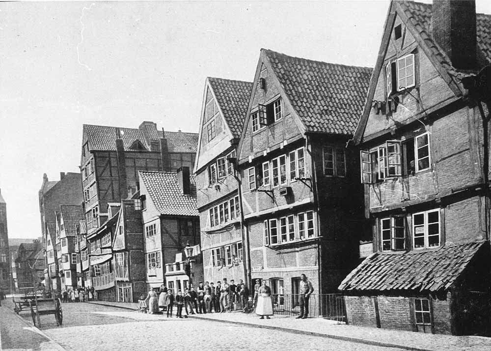
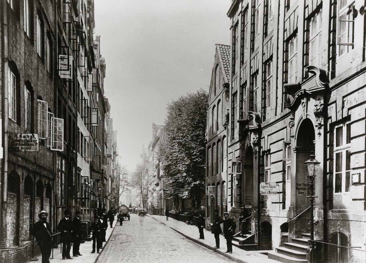
The site of today’s Speicherstadt was originally a complete district called Grasbrook, which stretched over several islands, built up over several centuries and was split into Großer Grasbrook in the north and Kleiner Grasbrook in the south. The district we are referring to is located on the former Kehrwieder-Wandrahm island and housed more than 20,000 people in more than 1000 residential buildings and warehouses. It was created during the 16th century when the first emigrants settled there. In the 17th century, immigrants, who were predominantly Dutch and Portuguese, built those picturesque three-storey half-timbered houses that characterised the image of the island until the late 19th century. The tip of Brook island was called ‘Kehrwieder’, in the middle was the ‘Brook’. Craftsmen and small businesses lived there, densely packed in half-timbered tenements. The term ‘Brook’, which is still in common use today and which appears again and again in Hamburg, comes from Low German and means ‘swampy area’, which is what Grasbrook was in its early days. The eastern part was known as Wandrahm. The local clothmakers coined this name, which was derived from the wooden frames used to stretch the cloth they used. The term ‘Kehrwieder’ is often associated with the farewell of sailors, for example when Hamburg sailors’ wives said goodbye to their husbands with “Bitte Kehr wieder” [Engl. Please come back]. In reality, ‘Kehrwieder’ simply means dead end, at the end of which one “turned back”.
Living on this ‘dead end’
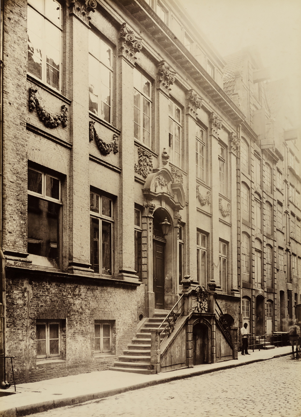
In 1567, the city of Hamburg became the destination for emigrants who had to leave their homeland for religious reasons. Thus, besides many Dutchmen, Portuguese Jews also settled in Hamburg and specifically on the Kehrwieder-Wandrahm island. The Hanseatic city welcomed the immigrants with open arms. Hamburg’s merchants in particular expected to gain new knowledge from foreigners and, above all, worldwide contacts and trading partners. It was the Dutch influence on Hamburg’s trade that did indeed grow steadily and unstoppably. In 1612, 32 of Hamburg’s 42 large trading houses were under Dutch management. Dutch had become the language of business and many Hamburg merchants kept their books in that language. Thus, Holländische Reihe, Holländische Brook, as well as Neuer and Alter Wandrahm were among the city’s most elegant streets. There, the ‘well-heeled’ and influential merchants lived in their baroque villas and merchant houses, while the people from the working classes were all to be found on Kehrwieder in impoverished and unhealthy living quarters. Also living and working in Alter and Neuer Wandrahm were the tenterers who had moved in from the Netherlands and processed the cloth for the cloth merchants. ‘Der Brook’, also known as ‘Schiffbauerbrook’, was considered one of the most heavily populated streets not only on the Kehrwieder-Wandrahm island, but in all of Hamburg. This was the home of the shipbuilders and carpenters whose profession gave name to the island. The construction of the Sandtorhafen port at Grasbrook in 1868 caused a slight wave of exodus by the more affluent residents, who now settled in the quieter Elbe suburbs or the Outer Alster. The parish of the local St. Katharinen church thus lost its wealthy and influential members, the entire area of Wandrahm and Kehrwieder became a dockworkers’ residential area. At the time of the construction of the Speicherstadt, Wandrahm was practically deserted, most of its villas and houses stood empty.
Sandtorhafen
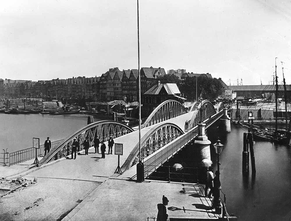
As early as 1850, Hamburg merchants had repeatedly and emphatically demanded that the port facilities be extended, as the handling of goods from deep-sea vessels was impossible in the existing waters. But first drafts based on the model of the London Docks did not garner much approval. It was only when Johannes Dalmann created a model based on an open tidal harbour did the project gained traction. Dalmann’s future harbour envisaged two harbour basins on Großer Grasbrook, in which ships with the greatest draught could moor. The project, which was to be funded in roughly equal parts from state and private funds, initially met with little enthusiasm from the Hamburg Senate. In 1860, however, after some improvements and changes, it finally adopted it as the general plan for the expansion of the port of Hamburg and in 1862 construction began at Sandtorkai. Thus, the first artificial harbour basin in Hamburg was created at Grasbrook with Sandtorhafen! It was particularly forward-looking that the construction of the docks and their sheds took into account not only transhipment on land – via railway tracks – but also the traditional Hamburg transhipment on water via lighters and barges. The barges and lighters could sail directly to the seagoing vessels moored at the docks and pick up the cargo for further transport. On 11 August 1866, Sandtorhafen was officially opened with a special ceremony. From 1869 to 1872, Sandtorhafen was extended by several docks on the opposite side and expanded by a large area.
Life in the alleyway district
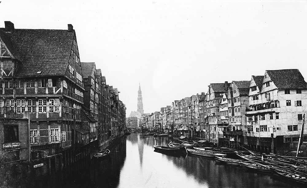
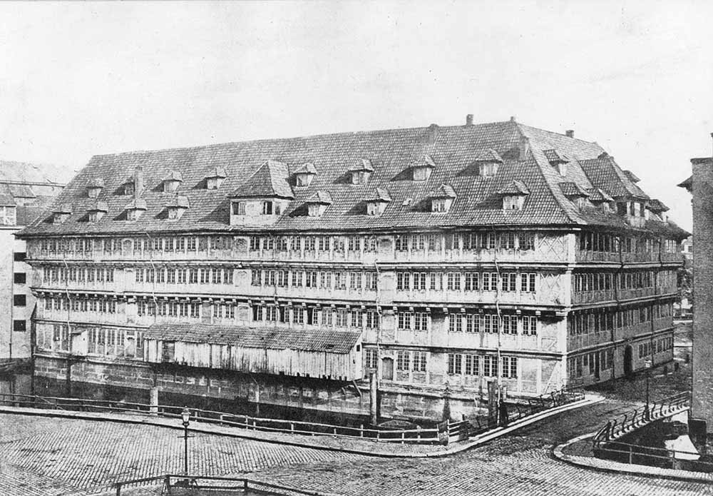
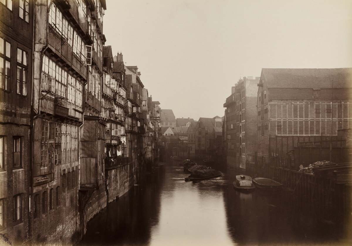
Somewhat off the beaten track, on the opposite shore of the Kehrwieder-Wandrahm island with its seafarers, craftsmen, merchants and tenterers, was one of Hamburg’s alleyway districts, those particularly densely built residential quarters in some parts of the old and new town of Hamburg. In streets like ‘Dovenfleet’ or ‘Bei dem Zippelhause’, the sight of low half-timbered houses standing close together, between which narrow courtyards with three or four rear buildings, accessible only through labyrinthine corridors, prevailed. That area was rightly considered one of the unhealthiest places to live in the Free and Hanseatic City of Hamburg. Due to its street level, the houses were regularly flooded at high tide and sometimes the water was so high that the furniture on the ground floor floated just below the ceiling. People stopped removing the silt dredged up by the high tide, as it would come back at some point again. The apartments themselves were small and so dark that lights of any kind had to be on all day long. The ceilings were so low that adults of the time were able to touch the ceiling with outstretched arms. They were extremely basic with rudimentary furnishings, and only in exceedingly rare cases had a connection to a water pipe. This alleyway district was also demolished to widen the customs canal as part of the customs union. In contrast to this, the merchants’ houses remained in Wandrahm. These apartment blocks combined residential and business premises of the resident merchant family, including the office and warehouse, plus a separate area for employees, all under one roof. The central point in the house was the two-storey foyer on the ground floor with a gallery running around on two sides, under which the kitchen was also located, unless it was built in the basement. Next to the hallway was the office, above which the living quarters were usually located. The warehouse was located above the foyer, where the goods were stored. Similar houses can still be seen north of the Speicherstadt on the island of Cremon. In contrast to this, were the pure office blocks called Kontorhäuser, as they were and can still be found in the Kontorhausviertel in Meßberg.
How people left the neighbourhood
After the customs union of the Free and Hanseatic City of Hamburg was resolved in 1881/1882 and the Kehrwieder-Wandrahm island and the alleyway district in the old town were designated as the area usable for the free port, the task was to clear the areas still inhabited by workers and migrants and to demolish the partly magnificent baroque houses from when the island was settled in the 17th century. The residents of St. Annen and Dovenfleet were given notice in November 1883.
However, where the now former inhabitants were to find shelter instead was up to each individual. This city made no effort and provided no support in this matter. As there was hardly any or no free capacity close to the port, the workplace of most displaced persons, they were forced to move to the surrounding villages outside of the city. Those who were lucky got something in Hammerbrook, those with less luck landed up in Wandsbek. This relocation meant that the already backbreaking job at the docks became even more arduous, as it now involved several hours of walking to and from work. Public transport was either not available or not affordable. It took until the end of March 1884 for the Kehrwieder-Wandrahm island to be abandoned by all its residents. Almost 24,000 people lost their homes, some of which had been passed down through generations, in the course of the construction of the customs union buildings.